

condensed from Chapter 9 of my book, "Dinosaurs -- An Adventist View"
One of the best proofs of the historicity of the worldwide Flood described in Scripture is the subsequent Ice Age that left clear traces around the world.
Discovery of the Ice Age
“I trust to outlive this mania,” wrote Louis Agassiz, referring to the mania of Darwinism. Agassiz was one of the last naturalists of undisputed eminence who never assented to Darwin’s theory of evolution. Born in 1807 to a Protestant minister in Switzerland, Agassiz studied at four European universities, earning doctorates of medicine and philosophy. At Paris, he studied comparative anatomy under the great Georges Cuvier, specializing in ichthyology—the study of fish. Cuvier had been planning to write a treatise on fossil fish, but he was so impressed with Agassiz that he gave Agassiz his notes and drawings on the topic. After Cuvier died, Agassiz accepted a position at the University of Neuchâtel, Switzerland, where he taught for fourteen years and published a treatise on fossil fish that established his scientific reputation.

Louis Agassiz (1807-1873)
At Neuchâtel, Agassiz began studying something completely unrelated to fish: glaciers. Another Swiss scientist, Jean de Charpentier, had suggested that glaciers had once been much more extensive than they now are. Agassiz was skeptical, but when he summered at de Charpentier’s hometown of Bex, Switzerland, his colleague showed him the evidence of extensive past glaciation. Agassiz threw himself into the study of glaciers. To save time, he set up shop right on top of a glacier, building a hut that came to be called “Hôtel des Neuchâtelois,” from which he and his students studied the structure and movements of the ice.
In 1840, Agassiz published Études sur les Glaciers (Studies on Glaciers), in which he argued that not only Switzerland but also many other regions had once been covered by vast ice sheets. “Great sheets of ice, resembling those now existing in Greenland,” wrote Agassiz, “once covered all the countries in which unstratified gravel (boulder drift) is found.”
Agassiz showed that glaciers leave distinctive geological traces. They carve out U-shaped valleys. They carry along boulders, called “erratics,” which come to rest far from their points of origin. They carry along dirt and gravel, and pile them in unstratified ridges called moraines. Lateral moraines form along the sides of the glaciers; terminal or end moraines at the farthest extent of the glacier’s advance. As glaciers move over the bedrock, they “polish” it, leaving scratches and grooves called striations. There are many other geological traces of glaciation, known by exotic names such as “cirque,” “esker,” and “drumlin.”
Even with the backing of prominent geologists like William Buckland and Charles Lyell, Agassiz’s glacial theory was slow to gain acceptance, and was not firmly accepted until the mid-1860s. Agassiz took a teaching job at Harvard, where he founded the Museum of Comparative Zoology. He was also instrumental in founding the National Academy of Sciences and was a regent of the Smithsonian Institution. He married a prominent Boston woman, Elizabeth Cabot Cary, and continued to teach America’s brightest science students until he died in 1873, having failed to outlive the mania of Darwinism.
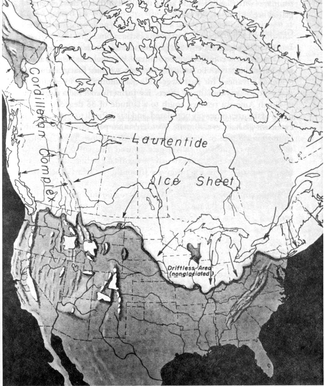
Glaciers once covered all of Canada and a substantial part of the United States. The glaciated areas of the U.S. include New England, as far south as northern New Jersey and northeastern Pennsylvania, and the Midwest, including most of Wisconsin, Illinois, Indiana, Ohio, and Missouri, and all of Minnesota, Michigan, and Iowa. The ice sheet extended west, covering parts of North and South Dakota and the northern edges of Montana, Idaho, and Washington.
Imagine the magnitude of the disaster if the Ice Age were to repeat itself, and the cities of Boston, New York, Cleveland, Detroit, Indianapolis, Chicago, Minneapolis, Milwaukee, Montreal, and Quebec were covered with thick glaciers, as their sites once were. The Ice Age will never repeat itself, however, because it was part of the aftermath of the Genesis Flood.
No Good “Mainstream” Explanation for the Ice Age
There is no good uniformitarian explanation for the Ice Age. Over sixty theories have been proposed; none were satisfactory, and most have been discarded.[1] “Pleistocene phenomena have produced an absolute riot of theories ranging from the remotely possible to the mutually contradictory and the palpably inadequate.”[2]
Charles Lyell theorized that vertical movements of the earth’s crust cause ice ages, noting that a general increase in land elevation would cause temperatures to drop because the atmosphere is colder at higher altitudes. But Lyell’s theory was discarded.
The explanation currently in vogue is the astronomical theory, proposed in 1864 by James Croll—a janitor at a college in Glasgow, Scotland—and substantially revised by the Serbian scientist Milutin Milankovitch (1879-1958) in the 1920s and 30s. The Milankovitch theory combined three celestial phenomena to explain the cooler weather: 1) cyclical changes in the eccentricity of the earth’s orbit around the sun, 2) small variations in the tilt of the earth’s axis relative to the plane of its orbit around the sun, and 3) the precession of the equinoxes.

Milankovitch is on the money, but his theory was not
The Milankovitch theory fell into disfavor in the 1950s, in part because it predicted dates for glacial advances and retreats that failed to correlate with Carbon-14 dating. By 1969, the vast majority of scientists had rejected it.[3] Yet the Milankovitch theory was resurrected in the late 1970s, thanks to the determined efforts of several influential scientists and to the fact that no one had proposed a better naturalistic explanation.[4]
The Milankovitch theory predicts a slight reduction in solar radiation at higher latitudes. This is simply not a sufficient explanation for such a profound change in the weather. Solar radiation is only one of the ways of heating the higher latitudes, and perhaps not the most important one. Ocean currents also provide a significant heat source for the higher latitudes. For example, the Atlantic Ocean’s Gulf Stream carries warm ocean water from the tropics into the northern hemisphere, where it exchanges heat with the atmosphere and helps warm North America and especially Great Britain and Northern Europe. Some climate scientists believe that the “little Ice Age,” a period of lower average temperatures that lasted from the mid-14th to the mid-19th century, was caused by derangement of the Gulf Stream.[5]
The Ice Age demands a much better explanation than just slight reductions in direct sunlight on the higher latitudes, and mainstream science has not produced any such explanation.[6]
The Creationist Theory of the Ice Age
In recent years, creationists, particularly Michael Oard, have developed an alternative explanation for the Ice Age. First, an Ice Age would not require colder winters. In fact, colder air works against the formation of glaciers, because Glaciers are made out of snow, and colder air cannot hold as much moisture and thus cannot precipitate as much snow. One of the coldest places on earth is Siberia, and it does not have glaciers.
The formation of the vast glaciers of the Ice Age required 1) much more snow; and 2) cooler summers, so that the glaciers would not melt back to their starting points each summer. The creationist model can supply both these conditions.
A. Greater precipitation
The first requirement for an ice age is greater snowfall. This is where the Milankovitch theory is weakest: it has no mechanism to produce the necessary precipitation. In the creationist model, the increased snowfall and generally greater precipitation is a result of greater evaporation from oceans that were substantially warmer during the early post-Flood period.
Although creationists have long held that the pre-Flood seas were warmer than today’s oceans, the Flood would have heated the water even more. Genesis 7:11 states that at the beginning of the Flood, “all the fountains of the great deep burst forth,” implying that water shot into the air from cracks or fissures in the earth. (Ellen White confirms this: “Jets of water burst from the earth with indescribable force, throwing massive rocks hundreds of feet into the air, and these, in falling, buried themselves deep in the ground.”[7]) Assuming that this water came from deep in the earth’s crust, it would be hot, because the crust of the earth grows about 20º to 30ºC warmer with each kilometer of depth. The temperature of subterranean water today can be as hot as 350ºC in geothermal vents along the mid-ocean ridges.[8]
Catastrophic plate tectonics theory provides an independent explanation for the heating of the oceans during the Flood. Molten magma rapidly erupted from the submarine ridges, forming new ocean floor as the continents moved apart. The ocean water must have absorbed immense heat in the process of cooling this new ocean floor basalt. We noted that a criticism of catastrophic plate tectonics theory is that the heat generated by such rapid seafloor spreading would have boiled the oceans. Clearly, the rapid seafloor spreading could easily have supplied the heat necessary to warm the oceans.[9] This process would have heated the oceans from the bottom, resulting in a more uniform, and uniformly warm, ocean temperature. Various lines of evidence indicate that the ocean floor water temperature was very warm at the end of the Flood and the beginning of the Ice Age.[10]
Warmer water evaporates much more quickly than cold water. The rate of evaporation depends upon the temperature of the water at the surface. For example, the rate of evaporation when the ocean surface temperature is 30º C is over three times greater than it is at 10º C and over seven times greater than it is at 0º C. (The current average ocean temperature is 4º C, but deep ocean water is just above freezing, whereas surface water averages 17.5º C).
The high rate of evaporation from the warmer post-Flood oceans led to greater precipitation. (Californians are familiar with the affects of “El Niño,” the current of warmer water that flows into the eastern Pacific Ocean every three to seven years, creating a much wetter winter.) Oard estimates that the average precipitation over mid- and high-latitude continents would have been at least triple the current rate. Larry Vardiman, a Ph.D. in atmospheric science, did a computer simulation of the precipitation that would have resulted from the heating of seawater during a rapid formation of new ocean floor. His computer simulation predicted a distribution of precipitation that closely tracked the actual distribution of snow and ice during the Ice Age.[11]
B. Cooler summers
The second requirement for an Ice Age is much cooler summers, and these are supplied by the greater volcanic activity in the first few centuries after the Flood. The modern view of volcanic activity is that much of it is caused by plate movement. Volcanoes tend to be clustered along the margins of plates and along submarine ridges. Most of the world’s active volcanoes are located near convergent plate boundaries where subduction is occurring, particularly around the Pacific basin.
In catastrophic plate tectonics theory, plate movement was extremely rapid during the Mesozoic and later stages of the Genesis Flood. During this time, vast quantities of new ocean floor were being formed, separating the continental plates of North and South America from those of Europe and Africa. We would expect to find evidence of hyperactive volcanism during the Flood and during the first few centuries after the Flood, and that is exactly what we find.
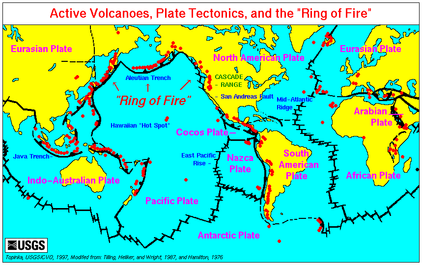
Volcanic activity is clustered on the edge of tectonic plates, and thought to be caused by plate subduction.
Subduction-zone volcanoes, like Mount St. Helens in Washington and Mount Pinatubo in the Philippines, typically erupt with tremendous explosive force, ejecting volcanic dust and ash high into the atmosphere. The upper Tertiary phase of the Flood witnessed numerous explosive conical volcanic eruptions.[12] In addition to the ejecta from conical volcanoes, enormous cataracts of lava flooded out of fissures in the earth opened by crustal rifting and continental breakup. These fissure eruptions, commonly called flood basalts, spewed aerosols into the upper atmosphere.[13] It is possible that, as the world emerged from the Flood, the skies were dark with volcanic ash and aerosols.[14]
Elevated volcanic activity continued into the Pleistocene—the post-Flood world of the Ice Age. Worldwide studies of volcanic ash layers in deep-sea sediments show that there was heightened volcanic activity during the Pleistocene. Much of the Ice Age volcanic activity was of the explosive type that would have ejected vast quantities of ash and aerosols into the upper atmosphere.[15] In the western U.S. alone, more than sixty-eight ash falls coinciding with the Pleistocene have been counted.[16] An exceptionally large Pleistocene eruption in New Zealand spread a distinct layer of ash over ten million square kilometers of the South Pacific. The amount of dust and aerosols thrown into the atmosphere by the largest of these eruptions would have blocked out most sunlight over the entire world.[17]
Lyellian assumptions space these eruptions by hundreds of thousands of years, over the course of millions of years, minimizing their effect on climate. But if all of these eruptions occurred within a few hundred years, they would have had drastic effects on the world’s climate. The dust and especially the aerosols that volcanoes eject into the upper atmosphere reflect solar radiation away from the earth, lowering temperatures. The effect is the same as the “nuclear winter” scenario frequently discussed during the Cold War years.
The cooling effect of volcanic eruptions is not disputed. Past volcanic eruptions have caused substantial cooling. The 1815 eruption of the Indonesian volcano Tambora lowered worldwide average temperatures by 3ºC (5º Fahrenheit), such that 1816 was known as “the year without a summer.” New England and Canada experienced an unprecedented series of cold snaps, with heavy snowfall in June and crop failures caused by frost in July and August.[18] The eruption of Krakatoa in 1883 caused a similar, though less severe, worldwide lowering of average temperatures.
A model in which all Pleistocene volcanic activity is telescoped into the space of a few hundred years predicts substantial summer cooling, so that the glaciers would not melt back each summer. Thus, the creationist Ice Age model provides both the greater precipitation and cooler summers necessary for the formation of the massive glaciers of the Ice Age.
Because the oceans tend to hold their temperature, atmospheric cooling would have lowered ocean temperatures slowly and gradually. The warmer water would always have risen to the top, because warmer water rises to the surface and cooler water sinks to the bottom. This would have allowed for greater evaporation and precipitation long into the Ice Age, despite the cooler summers.
Eventually, the factors that caused the Ice Age reversed themselves. The oceans cooled to their present temperatures, reducing evaporation and precipitation to current levels. Meanwhile, the rapid plate movements of the Flood and early post-Flood years decelerated to the present slow pace. Slowed tectonic activity reduced volcanic eruptions, which allowed the skies to clear of dust and aerosols, which in turn allowed the sun to warm up the earth. Warmer summers melted the continental glaciers back to their present locations, but the much colder oceans allowed ice caps to form at the poles.
Oard estimates that five hundred years were necessary to grow the ice sheets to their greatest extent, with an additional two hundred years needed for the ice to melt and retreat. Thus, the entire Ice “Age” could have lasted only about seven hundred years, easily fitting within the biblical time frame.
Explanatory Power of the Creationist Ice Age Theory
The greater precipitation predicted by the creationist Ice Age model explains the abundance of lakebeds in areas that are now desert, and the fact that existing lakes once had much higher water levels.[19] For example, the Great Salt Lake is the evaporated remnant of much larger Lake Bonneville. Vast reservoirs existed in the continental interiors, mainly because of greater precipitation in the early post-Flood centuries. Geologist Steven A. Austin suggests that the Grand Canyon was rapidly eroded when one of those reservoirs burst through a weak point in a natural dam.[20]
The creationist Ice Age model explains many other mysteries that cannot otherwise be explained.[21] Suffice it to say that biblical creationists, once reluctant to believe in a glacial age, are now quite enthusiastic about it. We have a better explanation for it than the long-ages geologists have.
finis
Notes:
[1] Oard, Michael J., “A Post-flood Ice-age Model can Account for Quaternary Features,” Origins 17(1):8-26 (1990), citing Eriksson, E. “Air-ocean-icecap interactions in relation to climatic fluctuations and glaciation cycles,” in J. M. Mitchell, Jr. (ed.), Causes of Climatic Change, Meteorological Monographs 8(30), (American Meteorological Society, Boston, 1968), pp. 68-92. See also Oard, Michael J., An Ice Age Caused by the Genesis Flood, (El Cajon, CA: Institute for Creation Research, 1990), p. 13.
[2] Oard, Michael J., An Ice Age Caused by the Genesis Flood, (El Cajon, CA: Institute for Creation Research, 1990) (hereinafter “Oard”), p. 13. citing Charlesworth, J. K., The Quaternary Era, (London: Edward Arnold, 1957).
[3] Imbrie, John and Katherine Palmer Imbrie, Ice Ages: Solving the Mystery (1986: Harvard University Press) at 141.
[4] Oard, at 16.
[5] See, e.g., Lemley, Brad, “The New Ice Age” Discover Vol. 23, No. 9 (September 2002).
[6] “[A] uniformitarian ice age seems meteorologically impossible, and proposed solutions to the problem are inadequate . . .” Oard, at 19. The eminent astronomer Sir Fred Hoyle wrote, “If I were to assert that a glacial condition could be induced in a room liberally supplied during winter with charged night-storage heaters simply by taking an ice cube into the room, the proposition would be no more unlikely than the Milankovitch theory.” Oard, at p. 18, citing, Hoyle, Fred, Ice, the Ultimate Human Catastrophe, (New York: Continuum, 1981), p. 77.
[7] White, Ellen G., Patriarchs and Prophets, (1890), p. 99.
[8] Oard, supra, citing Kerr, R. A., “Ocean Hot Springs Similar Around Globe,” Science 235:435 (1987).
[9] Wise, Kurt, Faith, Form, & Time, (Nashville, TN: Broadman & Holman, 2002), pp. 210-216.
[10] “The oxygen isotope and other data point to the startling conclusion that the deep ocean was much warmer than now during most of the last 100 million years.” Oard, at 71, citing Anonymous, (1978) Geological Perspectives on Climatic Change, National Academy of Sciences, Washington, DC. The last 100 million years, in conventional geochronology, correlates to Cretaceous through the Pleistocene or, in a creationist model, the later middle of the Flood through the early post-Flood centuries. Some scientists have estimated that water on the ocean bottoms was as warm as 55º F during the early Tertiary and had been even warmer during the late Cretaceous. Frakes, L.A., Climates throughout Geological Time, (New York: Elsevier, 1979), p. 190. While this is significantly warmer than present oceans, Oard believes the Floodwater oceans were warmer still.
[11] Vardiman, Larry, “Numerical simulation of precipitation induced by hot mid-ocean ridges,” Presented at the Fourth International Conference on Creationism Pittsburgh, PA, August 3-8, 1998.
[12] Cadet, J.-P., and Fujioka, K., (1980) “Neogene volcanic ashes and explosive volcanism: Japan Trench transect, Leg 57, Deep Sea Drilling Project. In von Huene, R., Nasu, N., et al., Init. Repts. DSDP, 56, 57 (Pt. 2): Washington (U.S. Govt. Printing Office), 1027-1041; Cadet, J.-P., Pouclet, A., Thisse, Y., Bardintzeff, J.M., and Azéma, J., (1982). “Middle America Neogene explosive volcanism and ash layers: evidence from the Middle America trench transect, Deep Sea Drilling Project Leg 67” In Aubouin, J., von Huene, R., et al., Init. Repts. DSDP, 67: Washington (U.S. Govt. Printing Office), 475-491
[13] The Columbia Plateau of Oregon and Washington is one example of such a continental flood basalt. Individual lava flows on the Columbia Plateau ranged from one hundred to five hundred feet thick, and in places the total accumulation is about three miles deep. It was once thought that flood basalts did not create a large volume of ash and aerosols. But flood basalt magmas are rich in dissolved sulphur, and it is now recognized that sulphuric acid aerosols, formed of sulphur volatiles such as sulphur dioxide, could be injected into the stratosphere, which would cause a long-lasting dry fog. Oard, at 69, 70, citing, Strothers, R.B., et al., (1986) “Basaltic Fissure Eruptions, Plume Heights, and Atmospheric Aerosols,” Geophysical Rresearch Letters, 13, pp. 725-728. “It has long been asserted that fissural basaltic eruptions could not have a global climatic impact. Recent work has shown that this was not the case. Detailed reconstruction of the history of . . . the 1783 Laki eruption in Iceland . . . one of the largest historical fissure eruptions, . . . has shown that it was responsible for some of the worst climatic change in a century in the Northern Hemisphere, leading to massive pollution, an ‘awesome’ sulphur-rich dry haze . . .” Courtillot, Thordarson, “Flood basalts appear to be the main cause of biological mass extinction in the Phanerozoic” Geophysical Reseach Abstracts, vol. 7 11196 (2005). The Columbia Plateau (CP) is dated to the Miocene. Others continental flood basalts include the Ethiopia Basalts (Oligocene, four times larger than CP), the Deccan Traps of India (Cretaceous/Tertiary, 8 times larger than CP), and seven other flood basalts dated to the Mesozoic, including the Karoo Dolerites of South Africa (Jurassic, more than 8 times larger than CP) and the Siberian Traps (Permian/Triassic, more than 8 times larger than CP).
[14] Interestingly, there are several Flood legends in which it is recorded that the sky was darkened. See the next chapter.
[15] Kennett, J.P., and Thunnell, R.C., (1975) “Global increase in Quaternary explosive volcanism,” Science, 187:497-503; Kennett, J.P., and Thunnell, R.C (1977) “On explosive Cenozoic volcanism and climatic implications,” Science, 196:1231-1234.
[16] Oard, at 69, citing Izett, G.A, “Volcanic Ash Beds; Recorders of Upper Cenozoic Silicic Pyroclastic Volcanism in the Western United States,” Journal of Geophysical Research, 86 (B11)(1981), pp. 10200-10222.
[17] Oard, at 69, citing Froggatt, P.C., “An Exceptionally Large Late Quaternary Eruption from New Zealand,” Nature, 319 (1986), pp. 578-582.
[18] Oard, at 34, citing Hughes, P., “The Year Without a Summer,” Weatherwise, 32(1979), pp. 108-111.
[19] Beneath the sands of the Sahara Desert is evidence of old river systems and forests, suggesting that the climate was once much wetter than today. Kurt Wise, Faith, Form, & Time, supra, at p. 215. Geologist Robert M. Schoch points out that the Sphinx shows evidence of much greater erosion from water than it should if Egypt was very arid at the time it was built. See, e.g., John Anthony West, Serpent in the Sky (Wheaton, IL: Quest Books 1993) pp. 186-220, 225-232; Graham Hancock, Heaven’s Mirror (New York: Crown Publishers, 1998) pp. 92-94. But the creationist Ice Age model, and particularly the higher precipitation that lasted for centuries after the Flood, may provide the solution to this riddle; the archeologists may not be as wrong about when the Sphinx was carved as geologists are wrong about how recently Egypt was wet and rainy. See, e.g., Kurt Wise, Faith, Form, & Time, supra, at p. 215.
[20] Austin, Steven A., Grand Canyon: Monument to Catastrophe (San Diego: Institute for Creation Research, 1994). See, also, Ed Stiles, “Is the Grand Canyon a Geologic Infant” UANews.org (University of Arizona) July 18, 2002 http://uanews.org/cgi-bin/WebObjects/UANews.woa/wa/MainStoryDetails?ArticleID=5820.
[21] One interesting mystery is that several maps from the sixteenth century show the continent of Antarctica, which is odd because the existence of Antarctica was not confirmed until the 1820s. Some of the maps, particularly the 1531 map of Oronteus Finaeus, show the ice-free coast of Antarctica with amazing accuracy, complete with mountain ranges and rivers going well inland. Now, and certainly in the 16th century, Antarctica is completely covered by thick glaciers, extending well out to sea. This and the fact that several 15th and 16th century maps are so accurate that they would have required the use of spherical trigonometry to produce, and the fact that they reflect the ability to accurately fix longitude (which was not achieved until the mid-18th century), led Charles Hapgood to the conclusion that these maps were copied from earlier maps going all the way back to a sophisticated Ice Age civilization that explored and mapped Antarctica. See Charles H. Hapgood, Maps of the Ancient Sea Kings, (Kempton, IL: Adventures Unlimited Press, 1966, 1996). Most have dismissed Hapgood as a crank, but his theory fits with the creationist Ice Age model. The warmer post-Flood oceans would have kept the coastal areas of Antarctica free of ice until the latter stages the Ice Age, when the oceans had cooled enough to allow the formation of icecaps at the poles. The sophisticated post-Flood people could easily have explored the coastal areas of Antarctica when they were still free of ice. See, e.g., Rene Noorbergen, Secrets of the Lost Races (Indianapolis, IN: The Bobbs-Merrill Company, 1977 (reprint: Brushton, NY: TEACH Services), pp. 96-99 (“this survey had to have been made shortly after the Flood when the land masses were left in their present forms, but before the ice began to accumulate at the poles.”)